-40%
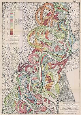
1944 Fisk Mississippi Ancient River Meander Belt snakes Alluvial Valley SH 2
$ 8.44
- Description
- Size Guide
Description
This Auction is for anUnframed
Authorized REPRINT
of an Antique Map as detailed below.
This map is printed on specially coated, matte finish, paper
for sharper print quality and colors that are vivid.
This Maps is created from
VERY high resolution uncompressed TIFF files
and are much sharper that the image shown here.
Original Map Details
Geological Investigation of the Alluvial Valley of the Lower Mississippi River
Harold Fisk, 1944
All 15 maps are this series are available from my store. Other maps from this report are also available.
In a report for the US Army Corps of Engineers, in 1944 Fisk had completed a mammoth effort entitled, “Geological Investigation of the Alluvial Valley of the Lower Mississippi River” The report and maps cover over 2,000 miles of river and its previous paths.
Included as part of the 60 maps above are the 15 maps of the "Ancient Meanderings of the Mississippi" this auction is for a reprint of one of those maps as detailed above.
One of the nice surprises from this report are a series of 15 maps that show the ancient meanderings of the Mississippi. The fifteen maps, stretching from southern Illinois to southern Louisana was his best attempt at tracking the meanderings of the Mississippi’s present and past bends, visualized as gorgeous maps.
A river doesn’t stay still. As it flows it carves out new paths in a route towards its ultimate destination. Over time, the bends and curves of what seems like river snakes coiling around one another. By looking at the geologic evidence, you can see the paths a river once took like looking at the past lives of the waters, the river’s ghosts.
The maps, scanned at high resolution and full scale, are some of the most beautiful I've seen. They are "nature's art" and make excellent display maps.
Approximate Image Size
16.5 X 24 inches
At top, the confluence of the Mississippi and Ohio Rivers as seen by Google Earth. On the bottom, the confluence as seen by Harold Fisk (1944).
Index map showing the assembly of the 15 maps (each sold seperately) of the ancient river meanderings
WE HAVE MANY HISTORIC REPRINT MAPS AND OTHER ITEMS ON MANY DIFFERENT SUBJECTS
Please check out store for additional products
Powered by
eBay Turbo Lister
The free listing tool. List your items fast and easy and manage your active items.
